


Charles Johnson Faulk Archival Collection
Preview
Preferred Citation
Faulk, Charles Johnson Jr., "Harper's Weekly 1863" (1863). Charles Johnson Faulk Archival Collection. 1127.
https://scholarsjunction.msstate.edu/mss-faulk-papers/1127
Description
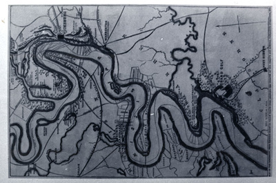
A map from Harper's Weekly showing the Mississippi River from Haines's Bluff to Grand Gulf. This shows land holdings along the Mississippi including the plantation of Jefferson Davis. This is handcolored.
Subjects
Maps and drawings
Date
1863
Geographic Location
Mississippi
Time Period
1854-1863
Object Type
stillimage
Format (Original)
photograph: b&w :
Format (Digital)
JPG
Digital ID
514_B31_F36_14
Physical ID
514_B31_F36_14
Related Materials
CHARM
Source
Mississippi State University Libraries, Special Collections Department, Manuscripts Division, Faulk (Charles Johnson) papers, Box 31, Folder 36
Digital Publisher
Mississippi State University Libraries (electronic version)
Rights
Copyright protected by Mississippi State University Libraries. Use of materials from this collection beyond the exceptions provided for in the Fair Use and Educational Use clauses of the U.S. Copyright Law may violate federal law. Permission to publish or reproduce is required.
Contact Information
For more information about the contents of this collection, email sp_coll@library.msstate.edu.
