


Charles Johnson Faulk Archival Collection
Preview
Preferred Citation
Faulk, Charles Johnson Jr., "Waterways Experiment Station" (1946). Charles Johnson Faulk Archival Collection. 1686.
https://scholarsjunction.msstate.edu/mss-faulk-papers/1686
Description
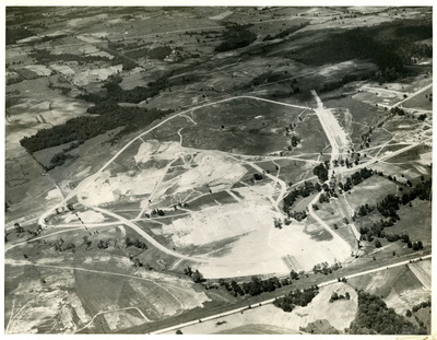
General view of Model Area. Looking from model East to West. The irregular ring road outlines of the model area of about 200 acres. The Ohio Basin is in the foreground; the Missouri-Mississippi Valley will follow the natural stream channel through the center of the model area; the Rocky Mountain highlands on the high ground in the middle distance. (Clinton Sub-office, U. S. W.E. S. Negative file No. CSO-A-3)
Subjects
U. S. Army Corps of Engineers Waterways
Date
1946
Geographic Location
Mississippi
Object Type
stillimage
Format (Original)
photograph: b&w : 19.3 X 26.7 cm.
Format (Digital)
JPG
Digital ID
514_B32_F14_20
Physical ID
514_B32_F14_20
Related Materials
CHARM
Source
Mississippi State University Libraries, Special Collections Department, Manuscripts Division, Faulk (Charles Johnson) papers, Box 32, Folder 14
Digital Publisher
Mississippi State University Libraries (electronic version)
Rights
Copyright protected by Mississippi State University Libraries. Use of materials from this collection beyond the exceptions provided for in the Fair Use and Educational Use clauses of the U.S. Copyright Law may violate federal law. Permission to publish or reproduce is required.
Contact Information
For more information about the contents of this collection, email sp_coll@library.msstate.edu.
