

Easter Flood, Jackson, 1979
Fifteen 8 by 10 original photographs taken aerially at the height of the Easter Flood of 1979. The photographs capture the devastation from downtown Jackson to Eastover and Lakeland Drive to Colonial Country Club and Colonial Mart to the Reservoir Dam. Most are labeled on their backs with descriptions of the location and view.
-

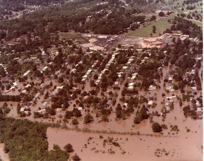
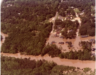
Aerial View of Flooding Around Colonial Club and Golf Course, Flooded Homes and Baptist Church South of Old Canton Road, Jackson, Mississippi
This sepia toned photograph depicts and aerial view of a golf course and club in the upper right, and homes and trees partially under water during a flood. The description on the back of the photo identifies the area as the Colonial Marts in the center, Colonial Club and golf course in the upper right, and the Baptist Church and homes south of Old Canton Road.
-

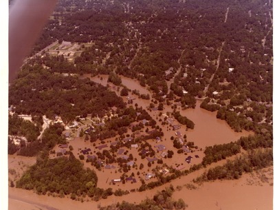
Aerial View of Flooding Around Covenant Presbyterian Church and Part of Eastover, Jackson, Mississippi
This sepia toned photograph depicts homes and trees underwater. The back of the photograph identifies the area as being the Covenant Presbyterian Church and part of Eastover.
-

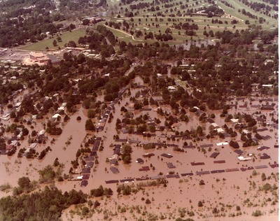
Aerial View of Flooding Around the Colonial Golf Course and Flooded Homes South of Old Canton Road, Jackson, Mississippi
This sepia toned photograph depicts homes and trees underwater due to flooding with a golf course visible near the top of the photo. The back of the photograph identifies the area as being the Colonial Golf Course and homes south of Old Canton Road.
-

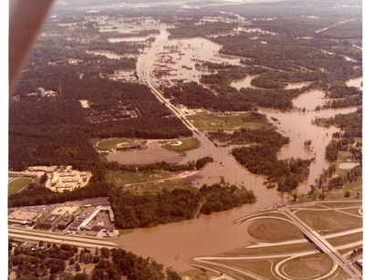
Aerial View of Flooding at Lakeland and I-55 North, Jackson, Mississippi
This sepia toned photograph features highways, trees, buildings, and open land under water due to flooding. The back of the photograph identifies the location as looking down Lakeland from I-55 North.
-

Aerial View of Flooding in a Residential Area, Jackson, Mississippi
This sepia toned photograph features trees, streets, and homes partially under water due to flooding.
-

Aerial View of Flooding in a Trailer Park in Jackson, Mississippi
This sepia toned photograph features trees, streets, and homes in a trailer park partially under water due to flooding.
-

Aerial View of Flooding in the Area of I-20 South of Jackson and the Coliseum, Jackson, Mississippi
This sepia toned photograph features trees, highways, buildings and an expanse of land partially under water due to flooding. The back of the card identifies this area as being Interstate Highway 20 South of Jackson, with the Coliseum and Highway 80 in view.
-

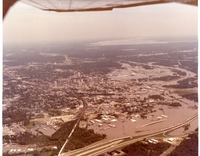
Aerial View of Flooding in the Deposit Guarantee Plaza Area of Downtown Jackson, Mississippi
This sepia toned photograph features the aerial view of streets, buildings and trees partially under water due to flooding. The back of the photo identifies the area as downtown Jackson, Mississippi with the Deposit Guarantee Plaza in the center.
-

Aerial View of Flooding in the Holiday Inn--Deposit Guarantee Plaza Area of Downtown Jackson
This sepia toned photograph features the aerial view of streets, buildings and trees partially under water due to flooding. The back of the photo identifies the area as downtown Jackson, Mississippi looking south from the Holiday Inn--Deposit Guarantee Plaza.
-

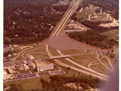
Aerial View of Flooding on Part of I-55 Near St. Dominic's Hospital, Jackson, Mississippi
This sepia toned photograph features a portion of a highway under water due to flooding. The back of the photograph identifies the area as being the portion of interstate highway 55 at Lakeland near St. Dominic's Hospital.
-

Aerial View of the City Auditorium, Art Center, and Petroleum Building in Downtown Jackson, Mississippi
This sepia toned photograph depicts the flooded area of Downtown Jackson. The back of the photograph identifies some of the buildings as being the City Auditorium, the New Art Center, and the Petroleum Building.
-

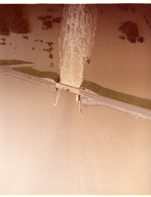
Aerial View of the Dam at the Reservoir Flooding, Jackson, Mississippi
This sepia toned photograph features water spilling from a dam and flooding the surrounding area. The back of the photograph identifies the location as the dam at the reservoir.
-

Aerial View of the Flooded Blackwell Chevrolet Buildings, Jackson, Mississippi
This sepia toned photograph depicts an aerial view of buildings and trees partially under water during a flood. The back of the photograph identifies the area as being the Blackwell Chevrolet car dealership.
-

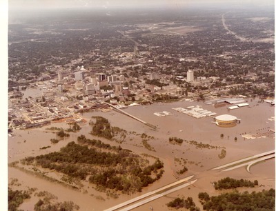
Aerial View of the Flooding Around Downtown and the Coliseum and Fairgrounds, Jackson, Mississippi
This sepia toned photograph depicts the aerial view of the buildings, trees, roads, and the coliseum partially under water due to flooding. The description on the back of the photograph identifies the area as Downtown Jackson, the Coliseum and fairgrounds, and Pearl Street at I-55.
-

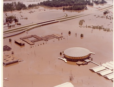
Aerial View of the Flooding at the Coliseum and the Coliseum-Ramada Inn, Jackson, Mississippi
This sepia toned photograph depicts an aerial view of the highway, buildings, the coliseum, and trees partially under water due to flooding. The back of the photograph identifies the area as the Coliseum and the Coliseum-Ramada Inn.
