


Hays Ray Webb Collection
Files
Download Full Text (7.5 MB)
Description
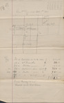
This diagram of land indicates public roads, cleared land, and timbered areas as well as directions and quadrant numbers. "Geo. P. Reynolds Oct 1st 1891" is written above the diagram indicating that the land represented in the diagram belongs to or has some relation to him. The statement written beneath the diagram indicates money earned in relation to the land.
Publication Date
10-1-1891
Time Period
1890-1899
Subjects
Land use; Charts, diagrams, etc.
Keywords
diagrams; land lots; land descriptions
Geographic Location
Attala County (Miss.)
Object Type
text
Format (original)
document
Format (digital)
Digital ID
MFM_MSS_004_1891-10-01_Diagram_001
Source
Mississippi State University Libraries, Archives and Special Collections Division, Manuscripts Unit, Hays-Ray-Webb Collection, Box 3, Folder 19
Repository
Manuscripts Unit
Digital Publisher
Mississippi State University Libraries (electronic version).
Rights
Copyright protected by Mississippi State University Libraries. Use of materials from this collection beyond the exceptions provided for in the Fair Use and Educational Use clauses of the U.S. Copyright Law may violate federal law. Permission to publish or reproduce is required.
Contact Information
For more information about the contents of this collection, email sp_coll@library.msstate.edu.
Recommended Citation
Hays-Ray-Webb collection, Archives and Special Collections Division, Mississippi State University Libraries, Mississippi State University
