


A.G. Wineman & Sons Records, and Wineman, Williams, Guice, and Stockwell et al Family Papers
Files
Download Full Text (2.0 MB)
Description
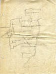
This hand drawn map includes the following Ohio counties, clockwise from left: Coshocton (Plainfield), Tuscarawas, Carroll (Leesville), Columbiana, Jefferson, Harrison, Belmont (Lloydsville, St. Clairville, Wheeling, Moundsville, and Barnesville), Monroe, and Guernsey (Cambridge). Moundsville, noted on this map as being part of Belmont County, Ohio is currently within Marshall County, West Virginia. The page shows several creases and two holes on the left margin.
Approximate Creation Date
1940
Time Period
1940-1949
Subjects
Maps; Counties; States
Keywords
Ohio; counties; towns
Object Type
image and text
Format (original)
map
Format (digital)
Digital ID
MSS_690_Box03_FF12_p001
Source
Mississippi State University Libraries, Archives and Special Collections Division, Manuscripts Unit, A.G. Wineman & Sons Records, and Wineman, Williams, Guice, and Stockwell et al Family Papers, Box 3, Folder 12
Repository
Manuscripts Unit
Digital Publisher
Mississippi State University Libraries (electronic version).
Rights
Copyright protected by Mississippi State University Libraries. Use of materials from this collection beyond the exceptions provided for in the Fair Use and Educational Use clauses of the U.S. Copyright Law may violate federal law. Permission to publish or
Contact Information
For more information about the contents of this collection, email [email protected].
Recommended Citation
A.G. Wineman & Sons Records, and Wineman, Williams, Guice, and Stockwell et al Family Papers, box 3, folder 12, Manuscripts Unit, Archives and Special Collections Division, Mississippi State University Libraries, Mississippi State University