


Files
Download Full Text (24.6 MB)
Description
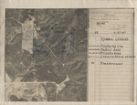
This conservation plan map was issued to J. F. (James Franklin) Buchanan by the U. S. Department of Agriculture Soil Conservation Service on February 27, 1967. The map provides an aerial view of the 59 acres in Leake County owned and operated by Buchanan and provides a symbol legend with indications for property lines, public and private roads, an intermittent stream and location of pine and hardwood.
Rights
Copyright protected by Mississippi State University Libraries. Use of materials from this collection beyond the exceptions provided for in the Fair Use and Educational Use clauses of the U.S. Copyright Law may violate federal law. Permission to publish or reproduce is required.
Approximate Creation Date
1967
Time Period
1960-1969
Subjects
Aerial photography in agriculture; Maps; Land use--Mapping
Keywords
aerial maps; conservation land maps; Leake County, MS; envelopes
Geographic Location
Leake County (Miss.)
Object Type
text
Format (original)
document
Format (digital)
Digital ID
MFM_MSS_854_1967-02-27_Conservation_Land-Map_001
Source
Mississippi State University Libraries, Archives and Special Collections Division, Manuscripts Unit, James Franklin "Frank" Buchanan Papers, Box 1, folder 20
Repository
Manuscripts Unit
Digital Publisher
Mississippi State University Libraries (electronic version).
Contact Information
For more information about the contents of this collection, email sp_coll@library.msstate.edu.
Recommended Citation
James Franklin "Frank" Buchanan Papers, Manuscripts Unit, Archives and Special Collections Division, Mississippi State University Libraries, Mississippi State University
