

Mississippi Coast Region
Files
Download Full Text (505 KB)
Contributor
NASA
Description
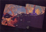
This color postcard features a map of the Gulf Coast including Lake Pontchartrain, the Breton Sound, the Chandeleur Sound, the Gulf of Mexico, the Mississippi Sound, coastal cities and Mobile Bay with the statistics Total Area 25,100 sq. miles/10 miles. The back of the postcard provides space for address. The top center of the card reads "John C. Stennis Space Center On the Gulf Coast in Hancock County, Mississippi." The description in the lower left corner reads "Space Remote Sensing--This image of the Louisiana, Mississippi and Alabama Coastline is a typical example of how scientists at NASA's John C. Stennis Space Center in Hancock County, Miss. turn satellite data into useful tools for better understanding the earth's natural processes. The science and technology laboratory is Stennis Space Center's primary scientific and research are responsible for developing tools and techniques to help manage the environment more effectively. Much time is being devoted to tropical forest management and shallow water oceanography to name a few with president Bush's goal of returning to the moon and then venturing out to Mars during the next century. More effort is also being placed in life sciences projects. This image of the Gulf Coast was created from landsat satellite multispectral scanner (MSS) data. Each color represents a different type of land cover."
Publication Date
1910
Publisher
NASA
Time Period
1890-1999
Subjects
Postcards; Maps; Gulf Coast
Geographic Location
Gulf Coast, US
Object Type
image
Format (original)
postcard
Format (digital)
Digital ID
MSS_837_Postcard_John-C-Stennis-Space-Center-Map_001
Source
Mississippi State University Libraries, Manuscripts Division, Lucius Marion Lampton, MD Historical Images Collection, Mississippiana Collection, Gulf Coast Sub-Collection
Repository
Manuscripts
Digital Publisher
Mississippi State University Libraries (electronic version)
Rights
Copyright protected by Mississippi State University Libraries. Use of materials from this collection beyond the exceptions provided for in the Fair Use and Educational Use clauses of the U.S. Copyright Law may violate federal law. Permission to publish or reproduce is required.
Contact Information
For more information about the contents of this collection, email sp_coll@library.MSState.edu.
Recommended Citation
Lucius Marion Lampton, MD Historical Images Collection, Special Collections Department, Mississippi State University