


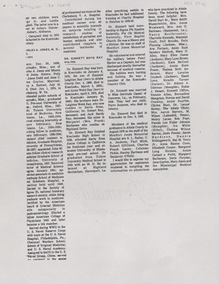
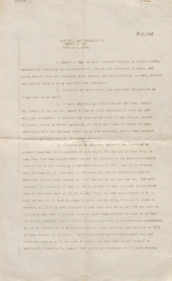
Hays Ray Webb Collection
The Hays Ray Webb digital collection is a collection of selected digitized materials from the Hays Ray Webb collection. The digtial collection contains family correspondence about the Civil War.
-

Letter, Sophia Boyd Andrews Hays to Matilda Ann "Lit" Boyd Webb, November 28, 1899
Sophia Boyd Andrews Hays
In this handwritten letter, dated November 28, 1899, Sophia Boyd Andrews Hays writes to her sister, Matilda Ann "Lit" Boyd Webb to let her know that she often thinks of her and wonders how her health is. She lets her know that her own health is good and gets around so well at times that she forgets that she is getting old. This letter was originally included with a group of letters addressed to Robert B. Webb, Annie Ray, and Matilda Ann "Lit" Boyd Webb.
-

Letter, Sophia Boyd Andrews Hays to Robert B. Webb, November 17, 1899
Sophia Boyd Andrews Hays
In this handwritten letter, dated November 17, 1899, Sophia Boyd Andrews Hays writes to her brother-in-law Robert B. Webb to express her shame at how long it took her to write to him. She explains that she has been busy. She goes on to discuss her brother, Gordan's (John Gordan Davis Boyd) health. She shares her thoughts on the manufacturing plant moving into Kosciusko and the positive effects that manufacturing establishments will bring to the South. This letter was originally included with a group of letters addressed to Robert B. Webb, Annie Ray, and Matilda Ann "Lit" Boyd Webb.
-
![Letter, from Robert Benson Webb to Matilda Ann "Lit" Boyd Webb, July 20, [1899] by Robert Benson Webb](https://scholarsjunction.msstate.edu/mss-webb-collection/1892/thumbnail.jpg "Letter, from Robert Benson Webb to Matilda Ann \"Lit\" Boyd Webb, July 20, [1899] by Robert Benson Webb")
Letter, from Robert Benson Webb to Matilda Ann "Lit" Boyd Webb, July 20, [1899]
Robert Benson Webb
In this handwritten letter Robert Webb writes from Lincoln County, Mississippi to his wife, Matilda to let her know he wrote to her from Jackson and tells her they'd had several incidents during their travels that cannot put into a short letter. He tells her he's feeling better than he did when he left home and describes the creek where they are stopped at to wait out the heavy rains. He goes on to discuss the number of miles he estimates that they have made thus far and what he expects from the rest of the trip.
-

Letter, from Robert Benson Webb to Matilda Ann "Lit" Boyd Webb, June 10, 1899
Robert Benson Webb
In this handwritten letter Robert Webb writes to his wife, Matilda and tells her what everyone has been doing while she has been away. He states how lonesome they all are for her but assures her they do not wish to hurry her home. The top and bottom edge of the pages are slightly torn.
-

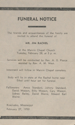
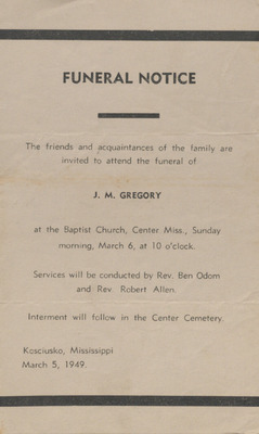
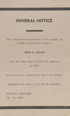
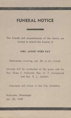
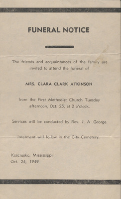
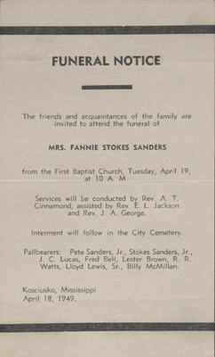
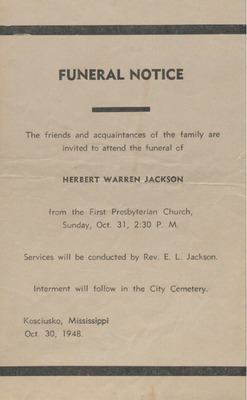
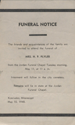
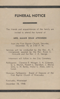
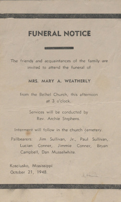
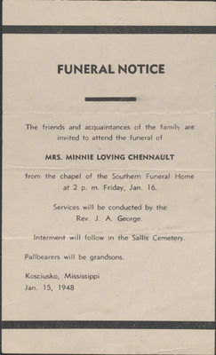
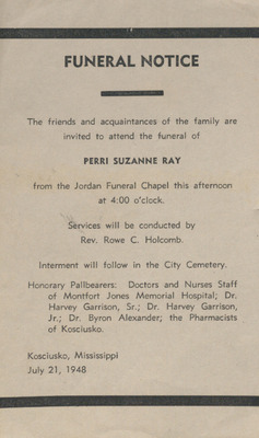
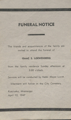
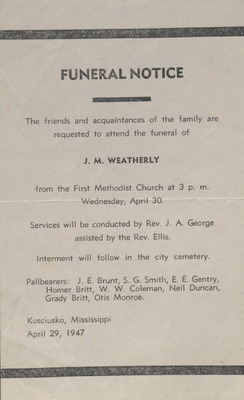
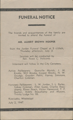
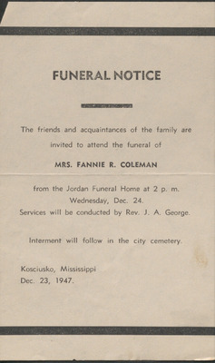
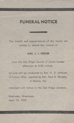
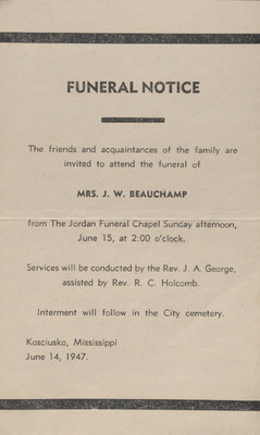
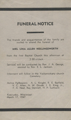
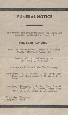
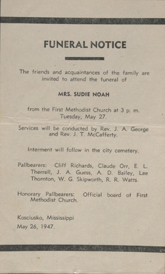
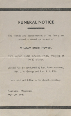
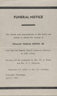
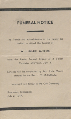
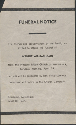
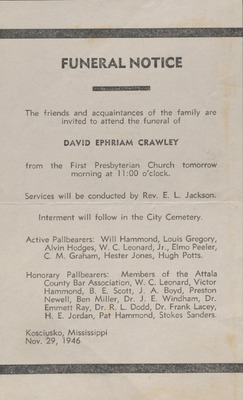
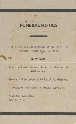
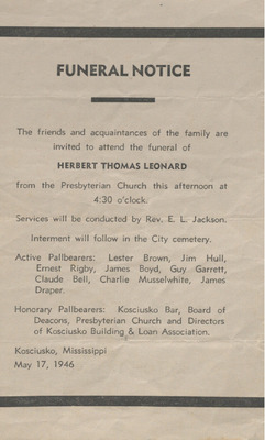
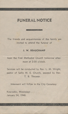
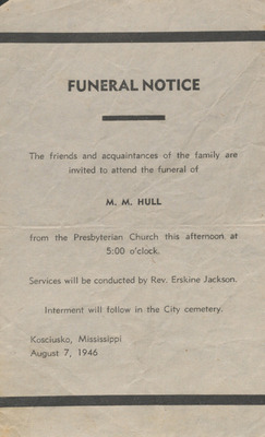
Funeral Notice, James F. Kelly, October 8, 1898
This funeral notice announces the funeral services of James F. Kelly of Kosciusko, Mississippi on October 8, 1898 with Reverend J. H. Alexander officiating.
-

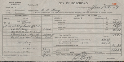
Receipt, R. B. Webb from Dodd and Armistead, February 8, 1898
This receipt documents R. B. Webb's payment of fifty dollars to be credited on his note of the three percent funds to be collected by Attala County, Mississippi Attorneys, Dodd and Armistead.
-
![Letter, from Boyd to His Grandparents [Robert B. and Matilda Ann "Lit" Boyd Webb], November 29, 1898 by Boyd](https://scholarsjunction.msstate.edu/mss-webb-collection/1911/thumbnail.jpg "Letter, from Boyd to His Grandparents [Robert B. and Matilda Ann \"Lit\" Boyd Webb], November 29, 1898 by Boyd")
Letter, from Boyd to His Grandparents [Robert B. and Matilda Ann "Lit" Boyd Webb], November 29, 1898
Boyd
In this handwritten letter, Boyd writes from Waco, Texas to his grandparents [Robert B. and Matilda Ann "Lit" Boyd Webb] in Kosciusko, Mississippi. He asks after all the family there, mentioning his Aunt Annie's marriage to Mr. Ray, asks after his cousins' education, and updates them on what he is studying at school.
-

Letter, from D. M. Claiton to Emmett Leighton Ray
D. M. Claiton
In this handwritten letter D. M. Claiton writes from Memphis, Tennessee to Emmet L. Ray in Kosciusko, Mississippi updating him on his job and home life. He goes on to discuss news he's heard of their mutual friends and ask after people in Kosciusko.
-

Envelope Addressed to Mrs. M. A. Webb, 1897
This empty envelope is addressed to Mrs. M. A. Webb [Matilda Ann "Lit" Boyd Webb] in Kosciusko, Mississippi. The envelope is postmarked Corinth, Mississippi May '87 [1897] and ink stamped "PAID" in the upper right corner.
-

Marriage Announcement, Mertie Caldwell to Sidney Johnson Whyte, June 10, 1896
In this card, the marriage of Mertie Caldwell and Sidney Johnson is announced to have been taken place on June 10, 1896 at Water Valley, Mississippi.
-

Marriage License, Emmet L. Ray to Annie Harriet Webb, November 17, 1896
This Attala County, Mississippi marriage license secures the rites of matrimony between Emmet L. Ray and Annie Harriet Webb, married on November 17, 1896, administered by W. W. Whitfield, minister of the gospel.
-

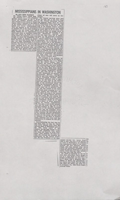
Newspaper Clipping, E. L. Ray and Annie C. Webb Wedding Announcement, November 20, 1896
This newspaper clipping from Kosciusko, Mississippi, announces the wedding of E. L. Ray and Annie C. Webb on November 17, 1896. The wedding took place at the home of the bride's father with Reverend W. W. Whitfield officiating. The announcement goes on to speak well of the couple and their individual accomplishments.
-
 Boyd, September 1896")
Newspaper Clipping, Jacob Hamilton (Hammie) Boyd, September 1896
This newspaper clipping shares the obituary of Jacob Hamilton "Hammie" Boyd who was born May 11, 1864 in Erath County, Texas and died on September 21, 1896 in El Passo, Texas. The obituary shares details the funeral that was held the Thursday following his death and a long eulogy of Boyd's life. The last letter he wrote to his mother prior to his death is included with the obituary.
-

Wedding Invitation, Jennie Lorena Hemphill to William L Temple, December 10, 1896
This invitation, extended by Mr. and Mrs. L. H. Hemphill, invites the recipient to attend the nuptials of their daughter, Jennie Lorena Hemphill to William L. Temple at the Methodist Church in Hattiesburg, Mississippi on December 10, 1896.
-

Letter, from Emmett Leighton Ray to Robert and Matilda Webb, October 1, 1896
Emmett L. Ray
In this handwritten letter, Emmett L. Ray writes to Robert and Matilda Webb asking for their consent to marry their daughter, Annie in November next. The letter is written on J. N. Alexander Dry Goods Groceries, Kosciusko letterhead. The paper shows wear and tearing at the creases and tearing at the bottom edge.
-

Letter, from Robert Benson Webb to Annie Webb Ray, May 23, 1896
Robert Benson Webb
In this handwritten letter, Robert B. Webb writes from Kosciusko, Mississippi to his daughter, Annie Webb Ray to update her on how the family has been getting along while she's been gone. He talks about their garden, Katherine's illness, and his inability to go fishing. He goes on to encourage her to enjoy her time and not hurry home and invites cousin Martha to come back with her when she does.
-

Letter, from Robert Benson Webb to Annie Webb Ray, May 31, 1896
Robert Benson Webb
In this handwritten letter, Robert B. Webb writes from Kosciusko, Mississippi to his daughter, Annie Webb Ray to update her on the family and friends in the community. He informs her of recent deaths, illnesses, the weather, the building of a college, and a wedding.
-

Deed for Land, John T. Lane to M. J. Ray, August 15, 1895
This deed, dated August 15, 1895, describes the sale of four acres of land in Attala County from John T. Lane to M. J. Ray at a cost of forty dollars. The deed is signed by Lane and is approved by Justice of the Peace, Frank Bell.
-

Deed for Lots, James P. Allen and Virginia R. Allen to W. L. Neal and M. A. Neal, December 28, 1895
This deed, dated December 28, 1895, describes the sale and conveyance of lots in Kosciusko, Mississippi from James P. Allen and Virginia R. Allen to W. L. Neal and M. A. Neal at a cost of one thousand five hundred dollars. The deed describes the lots and their locations. The deed is notarized by the Oklahoma notary public of Oklahoma City, MacGregory Douglas.
-

Letter, from Hattie to Robert B. Webb, December 15, 1895
Hattie
In this handwritten note, Hattie writes from Texas to her uncle, Robert B. Webb to send Christmas and New Year greetings. She goes on to update him on her family and encourages him to write Arthur Savage in New Orleans. The note is written on a one cent postcard.
-

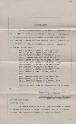
Deed of Conveyance, R. J. Bell and others to E. L. Ray, April 6, 1893
This deed, dated April 6, 1893, conveys E. L. Ray the lands in Attala County, Mississippi and provides the description of the land being conveyed. Five witnesses signed the deed of conveyance and the deed was certified by J. B. Rook, M. B. B. The Chancery Court filing information is included and signed by the Chancery Clerk on April 10, 1893.
-

Leather Slipper
A leather slipper worn by Lucy Lee Scarborough Chestnut as part of her wedding outfit in 1893.
-

Newspaper Clipping, The Ferris Wheel, 1893
This article from an unnamed newspaper details the changes made to the Christmas Eve night festivities wherein a smaller replica of the Ferris wheel at the Chicago World's Fair in place of a Christmas tree. The article goes on to describe how the wheel will work and what songs will be played. The clipping is torn near the bottom.
-

World's Columbian Exposition Ticket, October 9, 1893
This entry ticket allows admission on October 9, 1893 for the World's Columbian Exposition Chicago Day. The ticket includes the image of a phoenix rising from flames and the signature of H. K Higginbotham, exposition president. The ticket is number 15329.
-

Building Plan and Cost Assessment for Jasper F. Allen, July 24, 1892
This sheet contains the cost estimates and a basic floor plan drawing and includes lists of cost estimates for a building frame house with 2 rooms, 16 by 16 Hall shed, two rooms.
-
![Diagram of Land Associated with A. B. Alsworth, [1892]](https://scholarsjunction.msstate.edu/mss-webb-collection/2472/thumbnail.jpg "Diagram of Land Associated with A. B. Alsworth, [1892]")
Diagram of Land Associated with A. B. Alsworth, [1892]
This diagram of land includes lot numbers. "A. B. Alsworth" is written above the left of diagram indicating that the land represented in the diagram belongs to or has some relation to him. The statement written beneath the diagram indicates money earned in relation to the land.
-
![Diagram of Land Associated with A. E. Harmon, [1892]](https://scholarsjunction.msstate.edu/mss-webb-collection/2494/thumbnail.jpg "Diagram of Land Associated with A. E. Harmon, [1892]")
Diagram of Land Associated with A. E. Harmon, [1892]
This diagram of land includes creeks, timber, and lot numbers. "A. E. Harmon " is written on the back of the diagram indicating that the land represented in the diagram belongs to or has some relation to him. The statement written beneath the diagram indicates money earned in relation to the land.
-
![Diagram of Land Associated with Betty Hughes, [1892]](https://scholarsjunction.msstate.edu/mss-webb-collection/2493/thumbnail.jpg "Diagram of Land Associated with Betty Hughes, [1892]")
Diagram of Land Associated with Betty Hughes, [1892]
This diagram of land includes creeks, timber, and lot numbers. "Betty Hughes " is written on the back of the diagram indicating that the land represented in the diagram belongs to or has some relation to him. The statement written beneath the diagram indicates money earned in relation to the land.
-

Diagram of Land Associated with C. W. Carter, April 8, 1892
This diagram of land includes cultivated lots, timber, and lot numbers. "C. W. Carter " is written to the bottom left of the diagram indicating that the land represented in the diagram belongs to or has some relation to him. The statement written beneath the diagram indicates money earned in relation to the land.
-
![Diagram of Land Associated with Frank Rutherford, [1892]](https://scholarsjunction.msstate.edu/mss-webb-collection/2474/thumbnail.jpg "Diagram of Land Associated with Frank Rutherford, [1892]")
Diagram of Land Associated with Frank Rutherford, [1892]
This diagram of land includes roads are located and lot numbers. "Frank Rutherford " is written on the back of the diagram indicating that the land represented in the diagram belongs to or has some relation to him. The statement written beneath the diagram indicates money earned in relation to the land.
-
![Diagram of Land Associated with G. W. Ramson, [1892]](https://scholarsjunction.msstate.edu/mss-webb-collection/2473/thumbnail.jpg "Diagram of Land Associated with G. W. Ramson, [1892]")
Diagram of Land Associated with G. W. Ramson, [1892]
This diagram of land includes where dwellings are located and lot numbers. "G. W. Ramson" is written to the left of the diagram indicating that the land represented in the diagram belongs to or has some relation to him. The statement written beneath the diagram indicates money earned in relation to the land.
-
![Diagram of Land Associated with Heath __, [1892]](https://scholarsjunction.msstate.edu/mss-webb-collection/2470/thumbnail.jpg "Diagram of Land Associated with Heath __, [1892]")
Diagram of Land Associated with Heath __, [1892]
This diagram of land includes where roads are located. "Heath ___" is written on the back of the diagram indicating that the land represented in the diagram belongs to or has some relation to him. The statement written beneath the diagram indicates money earned in relation to the land.
-
![Diagram of Land Associated with Jack Brown, [1892]](https://scholarsjunction.msstate.edu/mss-webb-collection/2481/thumbnail.jpg "Diagram of Land Associated with Jack Brown, [1892]")
Diagram of Land Associated with Jack Brown, [1892]
This diagram of land includes lot numbers. "Jack Brown " is written above the diagram indicating that the land represented in the diagram belongs to or has some relation to him. The statement written beneath the diagram indicates money earned in relation to the land.
-

Diagram of Land Associated with James Ball, March 4, 1892
This diagram of land includes roads, cultivated lots, and lot numbers. "James Bell March 4 1892 " is written above the diagram indicating that the land represented in the diagram belongs to or has some relation to him. The statement written beneath the diagram indicates money earned in relation to the land.
-

Diagram of Land Associated with James W. White, February 21, 1892
This diagram of land includes roads, tenants, cultivated lots, residences, timber, and lot numbers. "James W. White" is written above the diagram indicating that the land represented in the diagram belongs to or has some relation to him. The statement written beneath the diagram indicates money earned in relation to the land.
-
![Diagram of Land Associated with J. A. Woods, [1892]](https://scholarsjunction.msstate.edu/mss-webb-collection/2484/thumbnail.jpg "Diagram of Land Associated with J. A. Woods, [1892]")
Diagram of Land Associated with J. A. Woods, [1892]
This diagram of land includes lot numbers. "J. A. Woods " is written above the diagram indicating that the land represented in the diagram belongs to or has some relation to him. The statement written beneath the diagram indicates money earned in relation to the land. Lot numbers and a smaller diagram are sideways on the bottom right of the page. R. H. Bell is listed as inspector on the back of the page.
-

Diagram of Land Associated with J. R. Horn, July 26, 1892
This diagram of land includes coordinates. "J. R. Horn" is above the diagram indicating that the land represented in the diagram belongs to or has some relation to him. The statement written beneath the diagram indicates the land's use including what crops are cultivated on which plot, where timber is located, and how much money is associated with it. Kosciusko, Mississippi is written on the back.
-
![Diagram of Land Associated with L. A. Baw, [1892]](https://scholarsjunction.msstate.edu/mss-webb-collection/2468/thumbnail.jpg "Diagram of Land Associated with L. A. Baw, [1892]")
Diagram of Land Associated with L. A. Baw, [1892]
This diagram of land includes where roads and residences are located. "L. A. Baw" is written on the back of the diagram indicating that the land represented in the diagram belongs to or has some relation to him. The statement written beneath the diagram indicates money earned in relation to the land.
-
![Diagram of Land Associated with N. N. Sweat, [1892]](https://scholarsjunction.msstate.edu/mss-webb-collection/2483/thumbnail.jpg "Diagram of Land Associated with N. N. Sweat, [1892]")
Diagram of Land Associated with N. N. Sweat, [1892]
This diagram of land includes roads, cultivated lots, timber, a church, and lot numbers. "Z. B. Guess " is written to the left of the diagram indicating that the land represented in the diagram belongs to or has some relation to him. The statement written it the right of the diagram indicates money earned in relation to the land.
-

Diagram of Land Associated with Perry N. Stuckey, January 8, 1892
This diagram of land includes where roads and residences are located. "Perry N. Stuckey Jany 8th 1892" is written above the diagram indicating that the land represented in the diagram belongs to or has some relation to him. The statement written beneath the diagram indicates money earned in relation to the land. The diagram is drawn on the back of a circuit clerk form.
-

Diagram of Land Associated with Sam H. Miller, Robert M. and Weldron Miller, February 18, 1892
This diagram of land includes roads, tenants, cultivated lots, residences, timber, and lot numbers. "Sam H. Miller, Robert M. and Weldron Miller Feby 18th 1892" is written above the diagram indicating that the land represented in the diagram belongs to or has some relation to him. The statement written beneath the diagram indicates money earned in relation to the land.
-

Diagram of Land Associated with Uriah B. Conner, February 23, 1892
This diagram of land includes cultivated lots, timber, and lot numbers. " Uriah B. Conner " is written above the diagram indicating that the land represented in the diagram belongs to or has some relation to him. The statement written beneath the diagram indicates money earned in relation to the land.
-
![Diagram of Land Associated with Warren Tyler, [1892]](https://scholarsjunction.msstate.edu/mss-webb-collection/2476/thumbnail.jpg "Diagram of Land Associated with Warren Tyler, [1892]")
Diagram of Land Associated with Warren Tyler, [1892]
This diagram of land includes where creeks and residences are located and lot numbers. "Warren Tyler " is written above the diagram indicating that the land represented in the diagram belongs to or has some relation to him. The statement written beneath the diagram indicates money earned in relation to the land.
-

Diagram of Land Associated with W. J. Lane, November 11, 1892
This diagram of land includes where roads, swamp, and timber are located. "W. J. Lane Nov 11 1892" is above the diagram indicating that the land represented in the diagram belongs to or has some relation to him. The statement written beneath the diagram indicates money earned in relation to the land. The diagram is drawn on G. R. Conner Clerk of the Chancery Court, Attala County, Kosciusko, Mississippi envelope.
-
![Diagram of Land Associated with W. J. Taylor, [1892]](https://scholarsjunction.msstate.edu/mss-webb-collection/2475/thumbnail.jpg "Diagram of Land Associated with W. J. Taylor, [1892]")
Diagram of Land Associated with W. J. Taylor, [1892]
This diagram of land includes roads are located and lot numbers. "W. J. Taylor " is written above the diagram indicating that the land represented in the diagram belongs to or has some relation to him. The statement written beneath the diagram indicates money earned in relation to the land.
-
![Diagram of Land Associated with Z. B. Guess, [1892]](https://scholarsjunction.msstate.edu/mss-webb-collection/2482/thumbnail.jpg "Diagram of Land Associated with Z. B. Guess, [1892]")
Diagram of Land Associated with Z. B. Guess, [1892]
This diagram of land includes lot numbers. "Z. B. Guess " is written to the left of the diagram indicating that the land represented in the diagram belongs to or has some relation to him. The statement written beneath the diagram indicates money earned in relation to the land.
-
![Diagram of Land on the Back of a Home and Farm Flyer, [1892]](https://scholarsjunction.msstate.edu/mss-webb-collection/2477/thumbnail.jpg "Diagram of Land on the Back of a Home and Farm Flyer, [1892]")
Diagram of Land on the Back of a Home and Farm Flyer, [1892]
This diagram of land, drawn on the back of Home and Farm flyer, includes where creeks and roads are located and lot numbers. No names or expenses are included with this diagram.
-
![Diagram of Land with Math Figures, [1892]](https://scholarsjunction.msstate.edu/mss-webb-collection/2471/thumbnail.jpg "Diagram of Land with Math Figures, [1892]")
Diagram of Land with Math Figures, [1892]
These two diagrams of land includes where roads, creeks, and cultivated lots are located. Coordinate numbers and mathematical figures are written on either side of the diagrams are on the back of the page.
-

Jenkins Abstract, undated
In this deed abstract, the ownership of a tract of land originally entered in May 1836 by Gordan Boyd is traced after his death. The land was inherited by his wife, then her second husband, and from there was deeded to Nathan Sweatt and his heirs.
-

Land Coordinates, Attala County, Mississippi, February 23, 1892
J. C. Sweatt's land coordinates are written on Attala County Circuit Court letterhead and the date, February 23, 1892 is written on the back of the page.
-

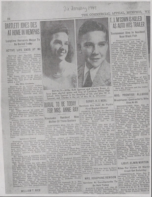
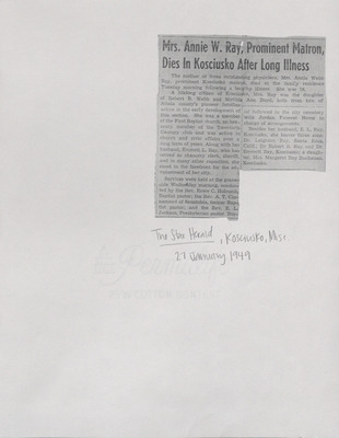
Newspaper Clipping, Carthaginian, Carthage, Mississippi, Margaret Ray Buchannan, September 16, 1982
This article on the society page of the Carthaginian details the events during the Dogwoods Trail Garden Club meeting at the home of Mrs. Becky Bell. Mrs. Margaret Ray Buchanan was the speaker for the meeting and demonstrated several types of table settings one might use while entertaining.
-

Property Appraisal, John M. Irving, September 29, 1892
This property appraisal includes a diagram of the sections of the property identifying what sections are used for cultivation, pasture, and timber. A list of each section, including dwellings and bottom land, is below the diagram and includes the appraised value of each section and their acreage. The types of buildings and dwellings are described and appraised at the bottom of the page. The second page identifies the property as that of John M. Irving and dated September 29, 1892. A note on the right states "Recommended Loan" beneath John Irving's name.
-

Property Appraisal, William and Lucy Cole, September 29, 1892
This property appraisal includes a diagram of the sections of the property identifying what sections are used for cultivation, pasture, and timber. A list of each section, including dwellings and bottom land, is below the diagram and includes the appraised value of each section and their acreage. The types of buildings and dwellings are described and appraised at the bottom of the page. The back of the page identifies the property as that of William and Lucy Cole and is dated September 29, 1892.
-

Small Diagram of Land Associated with J. A. Kern April 13, 1892
This small diagram of land is blank. "J. A. Kern April 13th 1892 " is written to the right of the diagram indicating that the land represented in the diagram belongs to or has some relation to him. The statement written to the right of the diagram coordinates, lot number acreage for each section.
-

Statement for J. R. Horn's Land, July 26, 1892
This statement for J. R. Horn's Land, dated July 26, 1892, lists the location, the type and amount of timber cut and what the amount earned.
-

Diagram, F. B. Brown's Land, February 25, 1891
This diagram of land includes public roads, cultivated lots, timber, and lot numbers. "F. D. Brown's Land Feby 25 1891" is written above the diagram. The statement written beneath the diagram indicates money earned in relation to the land.
-

Diagram of Land Associated with A. T. Middlebrook, February 6, 1891
This diagram of land includes where residences, timber, and cultivated lots are located. "A. T. Middlebrook, Feby 6, 1891" is written on the back of the diagram indicating that the land represented in the diagram belongs to or has some relation to him. The statement written beneath the diagram indicates money earned in relation to the land.
-

Diagram of Land Associated with B. M. H. P. an d J. L. Mullen, January 27, 1891
This diagram of land includes where roads, steam gin and mill, and residences are located. "B. M. H. P. an d J. L. Mullen Jany 27 1891" is on the back of the diagram indicating that the land represented in the diagram belongs to or has some relation to him. The statement written beneath the diagram indicates money earned in relation to the land. The diagram is drawn on the back of a circuit clerk form.
-

Diagram of Land Associated with Dallas O'Briant, 1891
This diagram of land indicates roads and cultivated land. "Dallas O'briant" is written above the diagram indicating that the land represented in the diagram belongs to or has some relation to him. The statement written beneath the diagram indicates money earned in relation to the land.
-

Diagram of Land Associated with George and William Smith, March 20, 1891
This diagram of land includes coordinate numbers in the sections. "Geo and Wm Smith March 20 1891" is written above the diagram indicating that the land represented in the diagram belongs to or has some relation to him. The statement written beneath the diagram indicates money earned in relation to the land.
-

Diagram of Land Associated with George P. Reynolds, October 1, 1891
This diagram of land indicates public roads, cleared land, and timbered areas as well as directions and quadrant numbers. "Geo. P. Reynolds Oct 1st 1891" is written above the diagram indicating that the land represented in the diagram belongs to or has some relation to him. The statement written beneath the diagram indicates money earned in relation to the land.
-

Diagram of Land Associated with G. W. Crowder, November 17, 1891
This diagram of land includes where timber and cultivated land is located and coordinate numbers in the sections. "G. W. Crowder Nov 17 1891" is written above the diagram indicating that the land represented in the diagram belongs to or has some relation to him. The statement written beneath the diagram indicates money earned in relation to the land. The diagram is written on the back of an State Experiment Station Agricultural College, Mississippi envelope that is addressed to R. B. Webb, Kosciusko.
-

Diagram of Land Associated with Harry Cain, February 26, 1891
This diagram of land includes coordinate numbers in three sections. "Harry Cain Feby 26 1891" is written above the diagram indicating that the land represented in the diagram belongs to or has some relation to him. The statement written beneath the diagram indicates money earned in relation to the land.
-

Diagram of Land Associated with J. C. Sweatt, 1891
This diagram of land indicates roads and cultivated land. "J. C. Sweatt" is written above the diagram indicating that the land represented in the diagram belongs to or has some relation to him. The statement written beneath the diagram indicates money earned in relation to the land. The diagram is drawn on Attala County Clerk of the Circuit Court letterhead.
-

Diagram of Land Associated with J. D. and W. P. Reminer, November 24, 1891
This diagram of land includes where cleared land and timber are located. "J. D. and W. P. Reminer Nov 24 1891" is written above the diagram indicating that the land represented in the diagram belongs to or has some relation to him. The statement written beneath the diagram indicates money earned in relation to the land.
-

Diagram of Land Associated with John H. Presley, undated
This diagram of land is blank on the front of the page and includes roads and residences. "John H. Presley" is written to the left of the diagram indicating that the land represented in the diagram belongs to or has some relation to him. The statement written beneath the diagram on the back of the page indicates money earned in relation to the land.
-

Diagram of Land Associated with Marion Bayarch, October 28, 1891
This diagram of land includes where a residence is located and coordinate numbers in the sections. "Marion Bayarch Oct 28th 1891" is written above the diagram indicating that the land represented in the diagram belongs to or has some relation to him. The statement written beneath the diagram indicates money earned in relation to the land.
-

Diagram of Land Associated with R. P. and J. T. Newell, February 1891
This diagram of land includes where roads, cultivated areas, timber and residences are located. "R. P. and J. T. Newell" is to the left of the diagram indicating that the land represented in the diagram belongs to or has some relation to him. The statement written beneath the diagram indicates money earned in relation to the land. The diagram is drawn on the back of a circuit clerk form.
-

Diagram of Land Associated with S. A. Haines, 1891
This diagram of land indicates roads. "S. A. Haines" is written below the diagram indicating that the land represented in the diagram belongs to or has some relation to him. Coordinates for the land are written beneath the diagram and a series of numbers are written above the diagram. The third page includes a statement that indicates money earned in relation to the land.
-

Diagram of Land Associated with Stonewall J. Baily, 1891
This diagram of land indicates cultivated and residential areas. as well as directions and quadrant numbers. "Stonewall J. Baily 27th 1891" is written above the diagram indicating that the land represented in the diagram belongs to or has some relation to him. The statement written to the right of the diagram indicates money earned in relation to the land.
-

Diagram of Land Associated with W. A. Peeler, November 25, 1891
This diagram of land includes where roads and residences are located. "William Peeler Nov 25 1891" is written above the diagram indicating that the land represented in the diagram belongs to or has some relation to him. The statement written beneath the diagram indicates money earned in relation to the land.
-

Diagram of Land Associated with Warren C. Whitehead November 30, 1891
This diagram of land indicates public roads, named private roads, and cultivated land as well as directions and quadrant numbers. "Warren C Whitehead, Nov. 30th 1891" is written above the diagram indicating that the land represented in the diagram belongs to or has some relation to him. Indications for other areas within the land are written on the lower right corner of the diagram with the coordinate numbers to designate where they're located. The statement written beneath the diagram indicates money earned in relation to the land.
-

Diagram of Land Associated with W. B. Gregory, October 13, 1891
This diagram of land includes where residences and timber are located. "W. B. Gregory Oct 13th 1891" is written above the diagram indicating that the land represented in the diagram belongs to or has some relation to him. The statement written beneath the diagram indicates money earned in relation to the land.
-

Diagram of Land Associated with Webster Gunter, November 18, 1891
This diagram of land includes where roads, timber and cultivated land is located and coordinate numbers in the sections. "Webster Gunter Nov 18 91" is written above the diagram indicating that the land represented in the diagram belongs to or has some relation to him. The statement written beneath the diagram indicates money earned in relation to the land.
-

Diagram of Land Associated with William W. Ashford, November 24, 1891
This diagram of land includes where cleared land and timber are located. "William W. Ashford Nov. 24th 1891" is written above the diagram indicating that the land represented in the diagram belongs to or has some relation to him. The statement written beneath the diagram indicates money earned in relation to the land.
-

Diagram of Land Associated with W. T. J. McElroy, September 7, 1891
This diagram of land includes where timber is located and coordinate numbers in the sections. "W. L. J. McElroy" is written above the diagram indicating that the land represented in the diagram belongs to or has some relation to him. The statement written beneath the diagram indicates money earned in relation to the land.
-

Diagram of Land, undated
This diagram of land includes where timber, a creek, and residences are located. The statement written to the right of the diagram on the back of the page indicates money earned in relation to the land. The back of the page includes a series of numbers and another diagram that only includes coordinates.
-

Diploma, Delson's Business College to Emmett L. Ray, July 21, 1891
This diploma, dated July 21, 1891, declares that Emmett L. Ray is a graduate of Delson's Business College in Memphis Tennessee. The diploma is signed by A. E. Nelson, the college president as well as the members of the board of examiners.
-

Land Quote, from J. C. Clark to W. J. Tyler, December 1, 1891
In this note written on J. C. Clark attorney stationary, prices for land and buildings are quoted to W. J. Tyler.
-

Land Value Estimate Statement, Elain Meek November 24, 1891
In this statement, dated November 24, 1891, Elain Meek's one hundred sixty-four acres of land, ninety of which are in cultivation, is estimated as being valued at one thousand five hundred dollars and the building valued at two hundred dollars. The location of the land is described as being seven and a half miles south of Kosciusko and instructions for who to contact for the fee is included. The statement is written on J. C. Clark Attorney-at-law.
-

Land Value Estimate Statement, W. H. Brister, November 27, 1891
In this statement, dated November 27, 1891,W. H. Brister's one hundred sixty acres of land is estimated as being valued at one thousand one hundred dollars and the building valued at three or four hundred dollars. Brister paid three hundred dollars for eighty acres in 1883 and four hundred and sixty dollars for eighty acres in 1887. The location of the land is described as being one half mile north of W. T. Singleton about three miles north of Herterville. The statement is written on J. C. Clark Attorney-at-law.
-

Land Value Estimate Statement, W. T. Singleton, November 24, 1891
In this statement, dated November 24, 1891, W. T. Singleton's eighty-eight acres of land, forty-five of which are in cultivation, is estimated as being valued at one thousand dollars and the building valued at three hundred dollars. The location of the land is described as being two and a half miles north of Ayers Shop adjoining G. R. Conner.
-

Newspaper Clipping, Eugene Story Hangs, June 2, 1891
This article from the Memphis Appeal-Avalanche details the execution by hanging of Eugene Story in Lexington, Mississippi (Holmes County). The article states that Story was convicted of murdering P. B. Kleinfelder and describes Story's walk up to the gallows as "Cool, audacious, and defiant to the last."
-

Scratch Paper
This scratch paper has the name "G. W. Foster" written at the top with some other words scratched through. Math figures are written in several places on the paper, both front and back.
-

Letter, Sophia Boyd Andrews Hays to Matilda Ann "Lit" Boyd Webb, November 8, 1891
Sophia Boyd Andrews Hays
In this handwritten letter, dated November 8, 1891, Sophia Boyd Andrews Hays writes to her sister, Matilda Ann "Lit" Boyd Webb to commiserate with her now that all of Lit's children have left home. She speaks of how she remembers the full house of children she used to visit and reflects on how things inevitably change.
-

Letter, W. S. Donald to R. B. Webb, March 12, 1891
W. S. Donald
In this letter, dated March 12, 1891, W. S. Donald writes to R. B. Webb to ask him to meet him in Goodman with a "new blank" and promises to pay all expenses. He adds that he owes S. L. Dodd some money and asks Webb to get him to wait until Webb returns. The bottom of the second page includes an upside down diagram of land and lists the costs included with it.
-

Letter, John W. Ivylee to R. B. Webb, March 19, 1891
John W. Ivylee
In this letter, dated March 19, 1891, John W. Ivylee writes to R. B. Webb to let him know that he sent a two dollar and fifty-cent Postal Note and asks Webb to let him know when he gets it. A second note informs Webb that the application he sent has been filed but a receipt will be delayed. The letter is written on United States Land Office letterhead and a Department of the Interior envelope is included.
-

Account Statement, R. B. Webb at Alexander and Morgan, Dry Goods, Clothing and Farming Implements, April 1, 1890
This handwritten account statement lists items purchased by R. B. Webb from Alexander and Morgan, Dealers in Dry Goods, Clothing, and Farming Implements in March 1890. The statement is marked paid by Alexander and Morgan on April 2, 1890.
-

Attala County, Mississippi Chancery Court Fee Bill for J. P. Marshall vs. O.C. Scarborough, April 4, 1890
This bill lists fees charged in the J. P. Marshall vs. O. C. Scarborough case for court fees associated with the Chancery Court in Attala County, Mississippi for the April 1890 term. Fees include Chancery Court Clerk fees, Sheriff's fees, and fees as master and commissioner. The bill, totaling thirty-three dollars and fifty-five cents, was certified by H. L. Land, the Chancery Court Clerk on April 4, 1890.
-

Banking House of C. C. Kelly Certificate of Deposit, R. B. Webb to Himself, December 03, 1890
This Banking House of C. C. Kelly certificate of deposit certifies that R. B. Webb deposited sixty dollars into his account. The certificate is signed by C. C. Kelly.
-

Clip-on Bow-tie
A cream colored clip-on bowtie with a embroidery on the corners of the bow. The bowtie is yellowed with age.
-

Deed for Land, Charles Bell to B. F. Ray, April 16, 1890
This certified copy of a deed, describes the sale and conveyance of land in Attala County from Charles Bell to B. F. Ray on April 16, 1890. The deed includes statements and signature of the Chancery Clerk and provides the dated the deed was filed and the certification information for this copy.
-

Diagram of Land Associated with G. W. Miller, December 1, 1890
This diagram of land indicates public roads, named private roads, quadrant numbers, and directions. "G. W. Miller Dec 1st 1890" is written beneath the diagram indicating that the land represented in the diagram belongs to or has some relation to him. The statement written below the diagram indicates money earned in relation to the land.
-

Diagram of Land Associated with J. F. Parkerson, December 2, 1890
This diagram of land indicates where timber is located, cultivated sections, and residences as well as directions and quadrant numbers. "J. F. Parkerson Dec 2nd 1890" is written to the left of the diagram indicating that the land represented in the diagram belongs to or has some relation to him. The statement written below the diagram indicates money earned in relation to the land.
-

Diagrams of Lots in Town with Land Descriptions, Undated
This document contains diagrams of lots in a town with land descriptions placing them at NW/4 of SE/4 27 147 and 26 147. Names of building/land owners are written within the lots in the diagrams. "The Sand" is written in pencil across the top of the page. There are some ink stains in the center of the page.
-

Elbow Length Gloves
A pair of elbow length gloves worn with a wedding dress. The gloves are discolored and badly wrinkled with age.
-

Farm Loan Application, J. H. Presley to J. C. Clark, December 1, 1890
This farm loan application documents the loan request made by J. H. Presley to J. C. Clark in Kosciusko, Mississippi. The amount requested is one thousand dollars to be paid in annual installments of five years at an interest rate of 10 percent. A questionnaire concerning the property is included.
-

Farm Loan Application, Joseph M. Weatherly to J. C. Clark, December 1, 1890
This farm loan application documents the loan request made by Joseph Weatherly to J. C. Clark in Kosciusko, Mississippi. The amount requested is six thousand dollars at an interest rate of 10 percent. A description of the property securing the loan and a questionnaire concerning the property is included.


